Coordinate Conversion
Advertisement

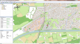
Eye4Software GPS Mapping Studio v.4.1
GPS Mapping Software for Windows, Loading topographic maps, Realtime navigation, GPS position tracking, Map import and export, Coordinate conversion and more
Advertisement
GPS Sway v.1.0
GPS Sway is a simple coordinate conversion program. It handles all forms of latitude and longitude (degrees, degrees minutes, degrees minutes seconds) as well as UTM coordinates and will convert from any form to another.

Geocaching_Toolbox v.1.0.0.0
Use this toolbox for common geocaching calculations and lookups. Text decypher, coordinate conversion, projection and table lookups.
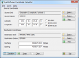
Eye4Software Coordinate Calculator v.3.2.12.208
Eye4Software Coordinate Calculator is a very easy to use tool to perform gps coordinate conversions. Supported projections: Transverse Mercator, Lambert Conformal Conic, UTM, Gauss Kruger, Stereographic, Albers Equal Area, Oblique Mercator and more.
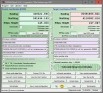
TRANSDAT v.20.37
TRANSDAT Coordinate Conversion supports thousands of coordinate systems and geodetic datum shifts, user-defined systems, INSPIRE, NTv2, BeTA2007, GPS, continental drift, Shape, KML, CSV and other file systems and much more with highest accuracy.
Blue Marble Desktop v.2. 2. 2001
The Blue Marble Desktop is the all in one geospatial data management platform for Blue Marble's popular data transformation tools.

TRANSDAT English v.17.75
TRANSDAT Coordinate Conversion supports thousands of coordinate systems and geodetic datum shifts, user-defined systems, INSPIRE, NTv2, BeTA2007, GPS, continental drift, Shape, KML, CSV and other file systems and much more with highest accuracy.
Geoida v.1.0
Geoida is a software product that will benefit members of the surveying and related professions for the day-to-day routine processing, coordination and adjustment of spatial survey data, from routine pick-up surveys to complex networks of geodetic sc

TRANSDAT Deutsch v.17.75
TRANSDAT Coordinate Conversion supports thousands of coordinate systems and geodetic datum shifts, user-defined systems, INSPIRE, NTv2, BeTA2007, GPS, continental drift, Shape, KML, CSV and other file systems and much more with highest accuracy.
SkunkWorks v.3.5.0.500
SkunkWorks is a Decal-based scripting tool for Asheron's Call. It allows you to automate aspects of your gameplay by writing macros in a variety of popular languages, including VBScript and JScript.
GeoVisu v.5.0.1
GeoVisu is a program that displays georeferenced data (images, graphics) and downloads data recorded by some GPS devices. GeoVisu has a 'Moving map' navigation function, which can be used with any NMEA 0183 compatible or Garmin USB GPS device.